It was great to find this Mount Katahdin climbing information over at summitpost.org
Welcome to Baxter State Park – Climb Mount Katahdin.
Katahdin is most impressive from the south, a sheer-like granite fortress towering to the heights. It’s shape is somewhat horseshoe-like with the open end heading northeasterly. Click this link to see an excellent overview photo. There are 5 main peaks on the horseshoe, counterclockwise from the north they go: Howe Peak, Hamlin Peak, Baxter Peak (summit), South Peak and Pamola Peak….
Katahdin is the highest mountain in Maine and the northern terminus of the Appalachian Trail. It is located within Baxter State Park, a wilderness-managed area in which humans come second that some refer to as the 51st state. The mountain, being a mile above sea level, towers above the comparatively low Maine lakes and forests. Due to the northerly latitude, timberline is at about 3,500 feet.
Our long-awaited summit day finally comes, albeit two years later than we anticipated it would be! We leave Katahdin Stream parking and hike up the Hunt Trail to summit and then hike down the Abol Trail to the Abol Campground. Thanks so much for following along on this great adventure with us for these past three years!
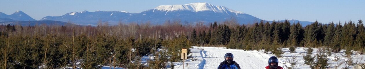
Here is a photo from 2017 of Mount Katahdin in the background as two snowmobilers pass. It was a crystal clear day and very cold. Perfect for taking this great shot! Thanks to Rick LeVasseur from 5 Lakes Lodge for the great photo and Maine-Snowmobiling.com for showing it to the world! Oh, and thanks for letting us share it, too!
Premiered Feb 22, 2022 – In this video, we hike up to Baxter Peak, the top of Mt. Katahdin in Maine using the Helon Taylor Trail. The section called the knife edge is a narrow, rocky hike along the ridge of the peaks for about a mile in length and about 360 feet of elevation change.
About the Knife Edge on Mt Katahdin
The Knife Edge Trail on Mount Katahdin is truly a hiker’s most breathtaking feat. Serving as one of the most popular places to hike, Mount Katahdin translates to the “greatest mountain” in Penobscot. Standing tall at 5,269 feet, the mountain is adjacent to Katahdin Woods and Waters National Monument, a prominent site for hikers to visit in the region. And though there are a ton of beautiful mountains to visit in the U.S, what makes Mount Katahdin’s “Knife Edge Trail” so breathtaking are the views from the top.
Mount Katahdin is the highest mountain in the U.S. state of Maine at 5,269 feet. Named Katahdin, which means “Great Mountain”, by the Penobscot Native Americans, it is within Northeast Piscataquis, Piscataquis County, and is the centerpiece of Baxter State Park. Wikipedia
The moose population in North America is shrinking swiftly. This decrease has been correlated to the opening of roadways and landscapes into this animal’s north range.
In North America, the moose range includes almost all of Canada and Alaska, the northern part of New England and New York, the upper Rocky Mountains, northern Minnesota and Wisconsin, Michigan’s Upper Peninsula, and Isle Royale.
Moose per square kilometer.
In 2014-2015, the North American moose population was measured at around one million animals.
The most abundant moose population (about 700,000) lives in Canada.
About 300 000 moose remains in nineteen U.S. states Alaska, Colorado, Connecticut, Idaho, Maine, Massachusetts, Minnesota, Montana, Michigan, Nevada, New Hampshire, New York, North Dakota, Oregon, Utah, Vermont, Washington, Wisconsin, and Wyoming.
The largest moose specimens are found in Alaska 200 thousand moose.
Below the map shows the size of US states scaled by the moose population.
States scaled by moose population
The moose (North America) or elk (Eurasia), Alces alces, is a member of the New World deer subfamily and is the largest and heaviest extant species in the deer family. Most adult male moose have distinctive broad, palmate (“open-hand shaped”) antlers; most other members of the deer family have antlers with a dendritic (“twig-like”) configuration.
Moose typically inhabit boreal forests and temperate broadleaf and mixed forests of the Northern Hemisphere in temperate to subarctic climates. Hunting and other human activities have caused a reduction in the size of the moose’s range over time.
It has been reintroduced to some of its former habitats. Currently, most moose occur in Canada, Alaska, New England (with Maine having the most of the lower 48 states), Fennoscandia, the Baltic states, and Russia. Its diet consists of both terrestrial and aquatic vegetation.
The most common moose predators are the gray wolf along with bears and humans. Unlike most other deer species, moose do not form herds and are solitary animals, aside from calves who remain with their mother until the cow begins estrus (typically at 18 months after birth of the calf), at which point the cow chases away young bulls.
Although generally slow-moving and sedentary, moose can become aggressive and move quickly if angered or startled. Their mating season in the autumn features energetic fights between males competing for a female.
Maine Moose – photo:
https://canoemaine.wordpress.com/